
Physical Models: Why You Can’t Plan Flow on a Flat Sheet of Paper
You cannot plan flow on a flat sheet of paper.
Here is the deal. Construction is a spatial business. Where do the cranes sit? Where does material land? How do crews move through the building without stacking on top of each other? Which zones release first, and what path does the work take through them? Those questions determine whether a project runs smoothly or fights itself for the entire duration, and they are almost impossible to answer well while staring at a two dimensional site plan. A 3D printed physical model, built to real world scale and placed on a table in front of the whole team, changes what the team is actually capable of seeing and deciding together.
The Pain of Planning Space Without Seeing Space
Picture a typical logistics planning meeting run entirely from drawings. The site plan is on the screen or spread across the table. Someone points at a section and describes where the tower crane will sit. Someone else nods, translating that flat rectangle on paper into a mental model of an actual sixty foot structure occupying real three dimensional space. A third person is trying to picture how material will travel from the laydown area shown on the drawing to the actual point of installation four floors up, a journey the drawing represents as a line but that in reality involves elevators, hoists, corridors, and dozens of other trades occupying the same path at different times.
Every person in that meeting is doing the same difficult mental translation independently, converting two dimensional information into a three dimensional understanding of how people, material, and equipment will actually move. Different people do that translation with different accuracy. Some are naturally strong at spatial reasoning from a drawing. Others struggle, and their struggle is invisible in the meeting because nobody can see what mental model anyone else is actually working from. The plan that emerges from that meeting reflects whichever person’s mental translation was loudest or most confident, not necessarily the most accurate one.
This is exactly where site logistics plans go wrong in ways that only become visible once construction is underway. Two trades scheduled to occupy the same access path at the same time. A crane positioned in a spot that made sense on the drawing but conflicts with a laydown area nobody flagged during planning. A path of travel for materials that looks clean on paper but requires navigating past columns, mechanical rooms, and stair towers that the flat drawing did not make visually obvious.
The Failure Pattern
The failure pattern is asking a team to make three dimensional decisions using two dimensional tools, and then being surprised when the decisions do not hold up once the project moves into real space.
A site plan is an accurate representation of the project, but accuracy is not the same as comprehensibility. A drawing can contain every dimension needed to build correctly while still failing to help a room full of people intuitively grasp how a sequence of work will actually flow through a building. That gap between what the drawing contains and what the team can actually absorb from it is where logistics planning goes wrong, not because anyone made an error reading the drawing, but because the format itself asks too much translation of every person in the room.
Most projects accept this gap as unavoidable. Site logistics get planned from drawings because drawings are what exists, and the resulting plan gets tested for the first time when construction actually begins, which is the most expensive possible moment to discover that a crane placement conflicts with a laydown area or that two trades were never going to be able to occupy the same corridor at the same time.
They Didn’t Fail the System
When a logistics plan falls apart once construction starts, crews stacking into the same zone, material paths that turn out to be impassable, a crane position that conflicts with an access route nobody caught, the instinct is to ask why the planning team missed something so obvious in hindsight.
The honest answer is usually that the conflict was never actually visible to the planning team, because the tool they were using to plan, a flat drawing, does not make spatial conflicts visually obvious the way a physical model does. A conflict that would be immediately apparent looking down at a scale model from above, two work zones physically overlapping, a crane’s swing radius crossing directly through a laydown area, can remain completely invisible on a drawing where those same elements are represented as lines and labels that require mental translation to actually understand as occupying the same physical space.
The planning team did not fail to notice something obvious. They were working with a tool that structurally hides certain kinds of conflicts, no matter how carefully anyone reviews it. Give that same team a physical model, and the conflicts that were invisible on paper often become immediately, visually obvious, not because the team suddenly became more careful, but because the tool itself surfaces information that a flat drawing cannot.
What a Physical Model Actually Changes
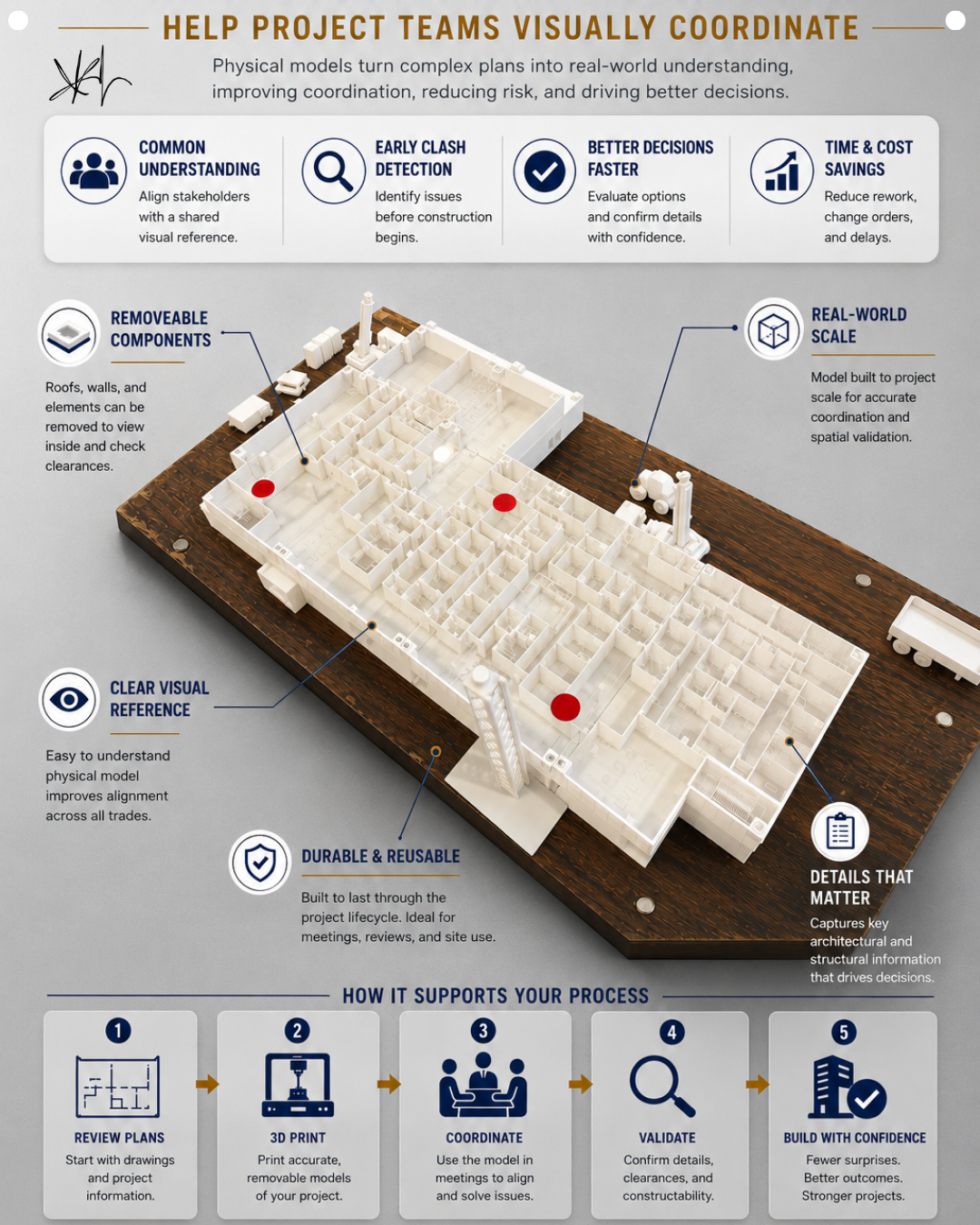
A common understanding is the first and most fundamental benefit. When the whole project team is looking at the same physical object, built to scale, there is no individual mental translation happening in isolation. Everyone in the room is aligned to a shared visual reference, which means a conversation about where the crane will sit is a conversation about an actual physical position on an actual physical model, not a description that each listener has to independently convert into their own mental picture.
Early clash detection becomes possible in a way that drawings rarely support intuitively. Identifying that two zones will conflict, that a crane’s position interferes with a planned laydown area, or that a path of travel crosses through a space that will be actively under construction, is dramatically easier when looking down at a scale model than when reading a site plan. This is spatial information, and physical models are the medium spatial information is naturally suited to.
Faster, more confident decisions follow directly from the previous two benefits. When the team shares a common understanding and can visually identify conflicts early, evaluating options and confirming details happens with far more confidence than debating an option that different people are still picturing differently in their own heads.
Reduced rework, change orders, and delays are the downstream financial consequence of catching spatial conflicts during planning instead of during construction. A crane placement conflict caught around a table with a model costs the time it takes to move a small physical piece and reconsider. The same conflict caught after the crane has actually been erected costs real money, real schedule, and a real disruption to whatever sequence depended on that crane being where it was planned to be.
The Specific Features That Make This Work
Removable components, roofs, walls, and individual elements that lift away, let the team see inside the model and check clearances that would otherwise be hidden behind an exterior surface. This matters specifically for planning crew flow through interior spaces, something a purely exterior model or a flat floor plan cannot show as intuitively as a model where you can physically remove a section and look inside.
Real world scale ensures the model supports accurate coordination and genuine spatial validation rather than a rough approximation. A model built to true scale means that distances, clearances, and relative positions on the model correspond meaningfully to actual distances and clearances on the real project, which is what makes it useful for genuine logistics validation rather than just a conversation aid.
Clear visual reference is what improves alignment across all trades specifically. A model that is easy to understand at a glance, without requiring specialized drawing literacy, means that every trade partner in a coordination meeting, regardless of their individual comfort reading construction documents, can participate in the conversation on equal footing.
Durability and reusability mean the model earns its cost over the full project lifecycle, used repeatedly across meetings, reviews, and ongoing site coordination rather than built once for a single presentation and then discarded.
And the details that matter, key architectural and structural information captured accurately in the model, ensure the tool actually drives real decisions rather than serving as a rough visual approximation that looks good but cannot bear the weight of genuine logistics planning.
The Process That Turns a Model Into a Planning Tool
A physical model only produces value if it is integrated into an actual planning process, and the process has five clear steps.
Review the plans first, starting with drawings and project information as the foundation everything else builds from. The model does not replace the drawing set. It translates it into a format the team can use more effectively for spatial coordination.
Print accurate, removable models of the project, ensuring the physical object faithfully represents the actual design rather than a simplified approximation that might miss the details that actually matter for coordination.
Coordinate by using the model in actual meetings to align the team and solve issues together, treating the model as a working tool in the room rather than a static display piece that gets admired and then set aside.
Validate details, clearances, and constructability using the physical reference the model provides, confirming that what looked workable in the abstract actually holds up when examined at scale with real spatial relationships visible.
And build with confidence, entering construction with fewer surprises because the team already walked the sequence, zone by zone, before a single crew mobilized to the site.
Why This Connects Directly to Takt Planning
A physical model is not a replacement for Takt planning. It is the tool that makes Takt planning genuinely spatial rather than purely schedule based. Takt planning defines zones and sequences. A physical model lets the team actually see those zones, walk the sequence visually, and confirm that the path the work takes through the building is physically coherent, not just logically coherent on a schedule.
Trade partners pointing at a model and planning their handoffs together in real time is Takt coordination made concrete. The abstraction of “Zone 3 releases to the mechanical trade on day four” becomes a physical conversation about an actual space, with actual clearances, that both trades can see and agree on together. If your project needs superintendent coaching, project support, or leadership development, Elevate Construction can help your field teams stabilize, schedule, and flow. Jason Schroeder and the LeanTakt team treat spatial planning tools like physical models as a natural extension of Takt discipline, because a schedule that is spatially sound is far more likely to hold than one planned entirely from a flat drawing.
Build the Model Before You Build the Building
Here is your challenge. Before your next major logistics planning meeting, whether it is crane placement, laydown planning, or a complex interior sequence, bring a physical model instead of relying solely on a drawing. Watch how quickly conflicts that would have stayed invisible on paper become obvious to everyone in the room at once.
The plan stops being abstract when everyone sees the same building, the same zones, the same flow. Build the team first, and give them something real to plan around.
On we go.
FAQ
Is a 3D printed model necessary, or can digital 3D models achieve the same result?
Digital 3D models offer real value and are already widely used for clash detection during design. A physical model adds a distinct benefit for group coordination meetings specifically, because everyone in the room can look at the same physical object simultaneously without needing a screen, a specific viewing angle, or someone controlling navigation. For collaborative logistics planning sessions with multiple trades in the room together, a physical model often produces faster alignment than passing control of a digital model back and forth.
How much does a physical model like this typically cost relative to the value it provides?
The cost varies significantly based on project scale and model detail, but the value case rests on preventing even a single significant logistics conflict from surfacing during construction rather than during planning. A crane placement error or a laydown conflict discovered after mobilization typically costs far more in rework, schedule impact, and coordination disruption than the model itself costs to produce.
At what phase of the project should a physical model be built?
Early enough that logistics decisions, crane placement, laydown areas, primary paths of travel, are still genuinely open for discussion rather than already locked in. Building the model after major logistics decisions have been finalized limits its usefulness to validation rather than genuine collaborative planning.
If you want to learn more we have:
-Takt Virtual Training: (Click here)
-Check out our Youtube channel for more info: (Click here)
-Listen to the Elevate Construction podcast: (Click here)
-Check out our training programs and certifications: (Click here)
-The Takt Book: (Click here)
Discover Jason’s Expertise:
Meet Jason Schroeder, the driving force behind Elevate Construction IST. As the company’s owner and principal consultant, he’s dedicated to taking construction to new heights. With a wealth of industry experience, he’s crafted the Field Engineer Boot Camp and Superintendent Boot Camp – intensive training programs engineered to cultivate top-tier leaders capable of steering their teams towards success. Jason’s vision? To expand his training initiatives across the nation, empowering construction firms to soar to unprecedented levels of excellence.